Problem Solution Technology Platform Team

We predict the invasion
before it hits.

BlueCrabNet turns satellite data, smart buoys and fishermen's reports into a 7-day forecast of where the blue crab will strike — so fishers, shellfish farmers and institutions can act before the damage, not after.

7-dayForecast horizon
Real-timeSmart buoy network
VenetoLagoon & Adriatic
Scroll

The problem

An unstoppable invader

The blue crab (Callinectes sapidus) was a curiosity in Italian waters for decades. In 2022 it exploded — and the lagoon economy has been chasing it ever since.
1949
First catch recorded in Italy. Irrelevant for over seventy years.
2022 — the boom
Population erupts in the northern Adriatic. 97 tonnes landed.
2024
713 tonnes landed — a +600% surge in two years.
2025
Reaches Mantova, 160 km up the Po. The Mediterranean is next.
1949
First catch in Italy
+600%
Growth: 97t (2022) → 713t (2024)
€100M
Estimated damage in Italy
2M
Eggs per female, every summer
22
Countries now at risk across the Mediterranean
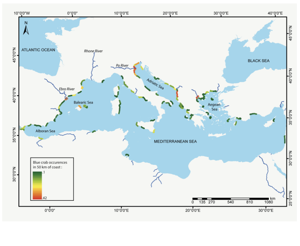
Map of the Mediterranean showing where the blue crab is already present
Today: where the crab is already present.
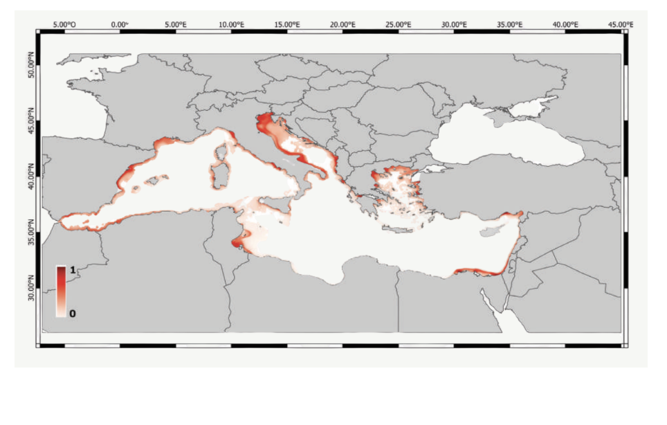
Map of the Mediterranean showing where environmental conditions are already favorable for the blue crab
Tomorrow: where conditions are already favorable.

Ground zero

Why Veneto is the epicentre

Veneto is where the invasion turned from anecdote into emergency. The lagoon's brackish, nutrient-rich water is a perfect nursery — and the crab is already pushing inland, up the Po.
3,000+
Aquaculture farms hit
in the Po Delta alone — clam and mussel beds devastated.
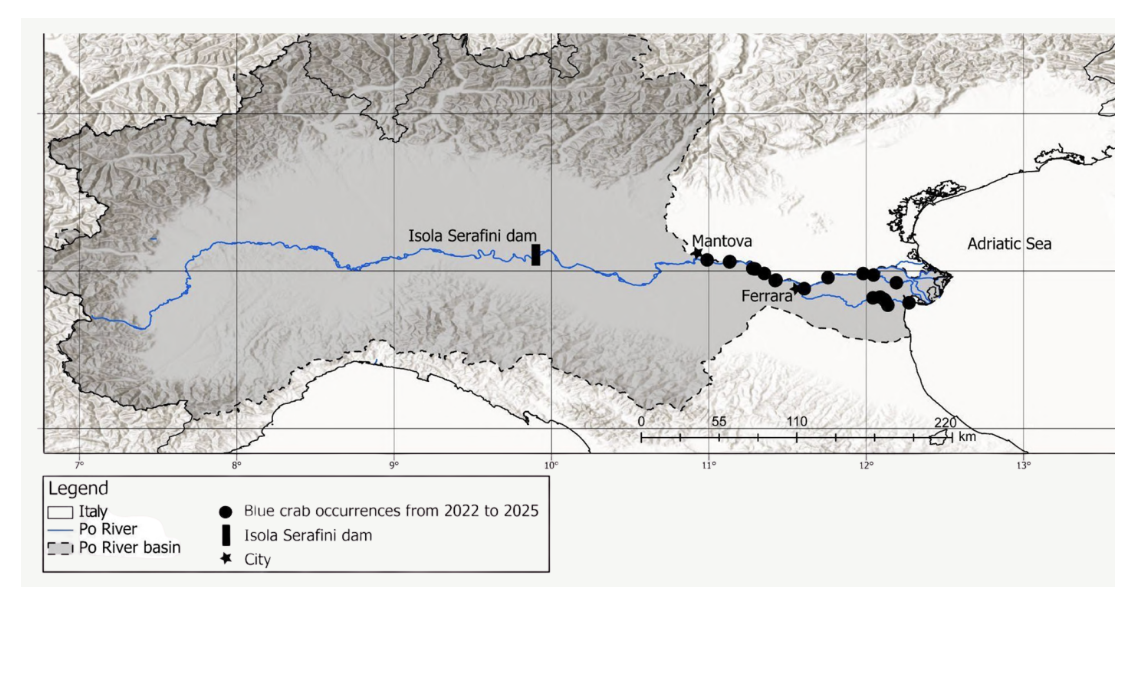
160 km
Upstream spread along the Po
from the rivermouth to Mantova between 2022 and 2025.
#1
Italy's hardest-hit region
Veneto sits at the front line of the entire Mediterranean expansion.
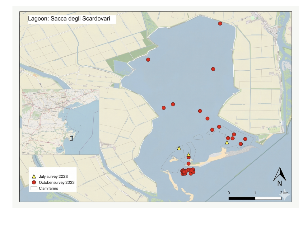
Map of sampling sites in Sacca degli Scardovari lagoon
Sampling sites in Sacca degli Scardovari.
Map showing upstream spread of the blue crab along the Po River to Mantova, 2022 to 2025
Upstream spread along the Po: 160 km from the mouth to Mantova, 2022–2025.

The gap

Existing solutions fail

Every current response shares the same flaw: it reacts to a crab that has already arrived. None of them tells anyone where it will be next.

Hunting & compensations

€47M in reimbursements and capture nets, 212 strategic points, regional consortia. Effort without foresight.

Reactive · acts too late

Blue crab as a resource

E-commerce, recipes, industrial supply chains, pharma scrap. Real value — but only a niche use.

Depends on unplanned supply

Theoretical studies

Validated predictors and institutional monitoring from research bodies — papers, not products.

No operational output

There is no network. There are no forecasts.
BlueCrabNet builds both.

The solution

From space to lagoon

Three streams of data flow into a single AI model — and out comes one 7-day forecast, shaped for the three groups who need it most.
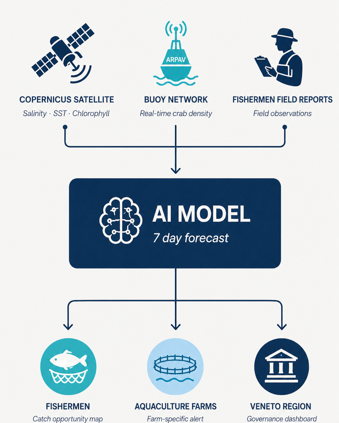
Data fusion diagram: Copernicus satellite, buoy network and fishermen field reports flow into an AI model producing a 7-day forecast for fishermen, aquaculture farms and the Veneto Region.

What Copernicus measures

Open satellite data on the conditions that decide where the crab can thrive.

Temperature

Optimal 18 °C – 30 °C
Copernicus Marine — Mediterranean Sea High-Resolution Surface Temperature

Chlorophyll-a

Food-chain richness
Maps predator distribution against habitat carrying capacity — Mediterranean Sea Biogeochemistry Analysis & Forecast

Salinity

Optimal 5 – 25 PSU
Copernicus Marine — Mediterranean Sea Physics Analysis & Forecast

The hardware

Smart buoys that attract & detect

A self-powered surface node and a baited underwater structure — one device that lures crabs in, counts them with on-board AI, and streams the readings home.
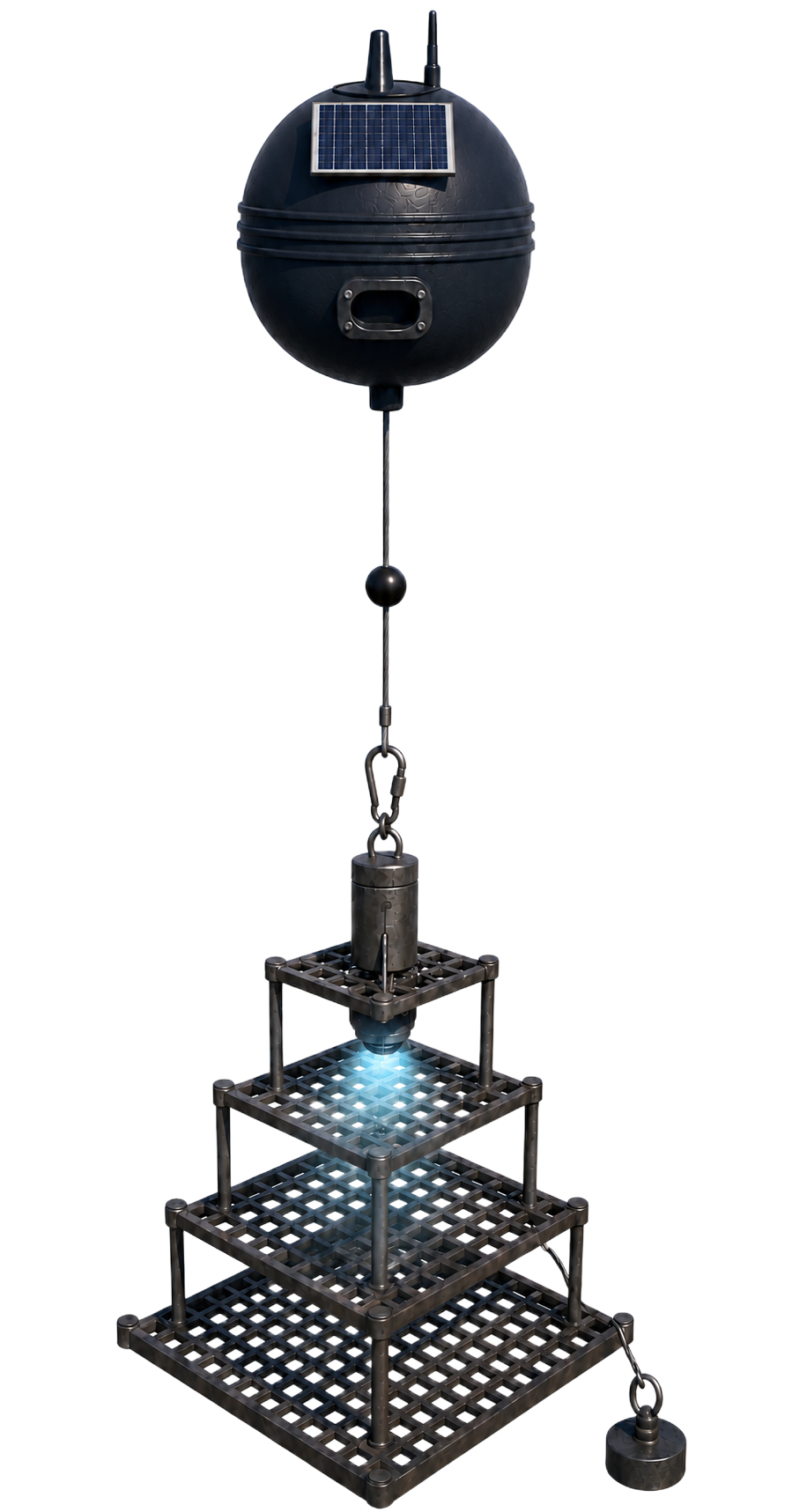
Render of a BlueCrabNet smart buoy: a solar-powered surface float tethered to an underwater habitat cage with camera and trap.
Surface node
Solar panelAutonomous power
LoRa antenna30-min transmission
Galileo GPSHigh-precision position
Environmental sensorsTemp · salinity · O₂
Underwater structure
Habitat moduleAttracts crabs
360° HD cameraReal-time AI counting
BallastStable in currents
Adjustable tether — up to 30 m
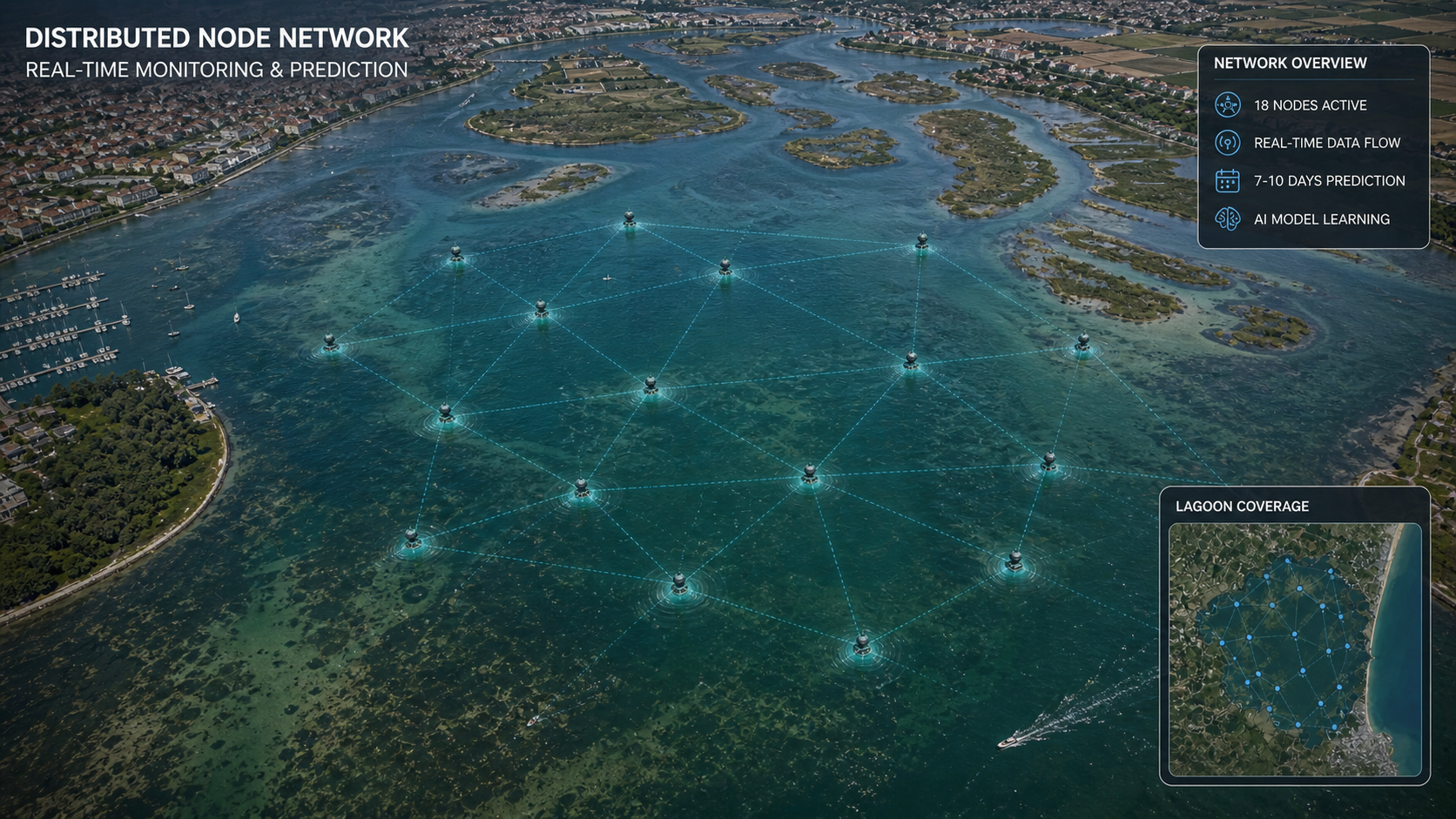
Aerial view of the Venetian lagoon overlaid with a distributed network of BlueCrabNet monitoring buoys connected in real time.

One buoy becomes a living network

Dozens of nodes across the lagoon feed the model continuously — turning isolated readings into a real-time map of the whole coast.

The platform

See the whole coast, seven days ahead

Monitor the buoy network in real time. Forecast crab density 7 days ahead from Copernicus and field data. Report your catch with location, photo and quantity — and feed the network.
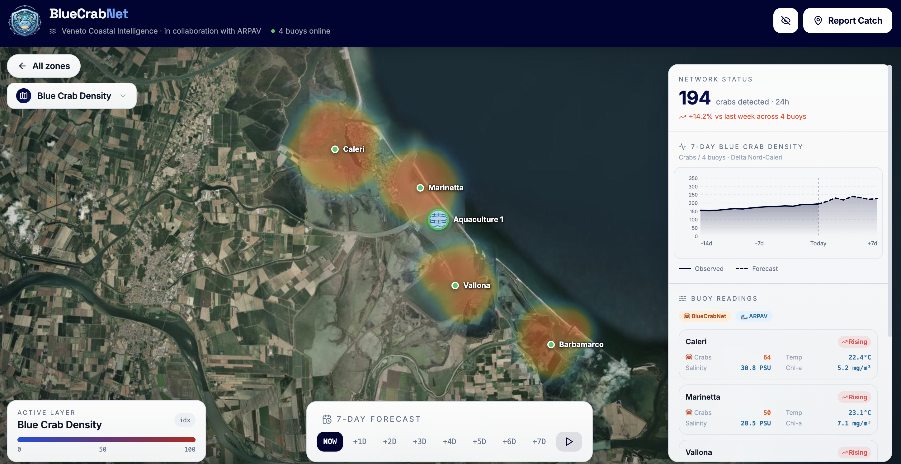
bluecrabnet.netlify.app
BlueCrabNet platform: a live satellite map of the Veneto coast with buoy markers showing crab density, a 7-day forecast chart and live buoy readings.

Impact

Who we serve

Fishermen

Fish where it counts. A catch-opportunity map means less wasted fuel and fuller nets.

Shellfish farmers

7-day alerts protect a whole season of stock — react to threats before they reach the beds.

Institutions

Spend on prevention, not just compensation. A governance dashboard for the whole region.

Everyone reacts. We predict.

The team

Built by engineers, data scientists & statisticians

Alessandro Sartore
Alessandro Sartore
MSc Artificial Intelligence @ UniTn
Andrea Dragonetti
Andrea Dragonetti
MSc Statistics @ UniPd
Fabio Missagia
Fabio Missagia
MSc CS: Data Science @ UniTn
Luca Tecchio
Luca Tecchio
Software Engineer @ Würth IT
Ludovico Cappellato
Ludovico Cappellato
MSc CS: Cybersecurity @ UniTn
Sara Cerlenco
Sara Cerlenco
BSc Computer Science @ UniTn
Stefania La Rosa
Stefania La Rosa
BSc Computer Science @ UniTn

Get in touch

Work with us

Fishermen, aquaculture operators, researchers and public authorities — send us a message and we'll get back to you.